By Nyang’au Araka and The Guardian
For generations of Kenyan schoolchildren, Africa has appeared on classroom maps looking strangely smaller than it really is.
Now, that familiar picture could begin to change.
Also Read
The United Nations General Assembly has voted to phase out the centuries-old Mercator map projection in favour of maps that more accurately represent the size of Africa and other parts of the world.
The resolution, sponsored by Togo on behalf of the African Union, was backed by 164 countries. The United States voted against it, while six countries abstained.
For Kenyans accustomed to seeing Africa squeezed between Europe and other continents on classroom maps, the change is more than a cartography lesson.
Supporters say it is about correcting how generations have visually understood the continent.
The Mercator projection, created by Flemish cartographer Gerardus Mercator in 1569, was designed mainly to help sailors navigate.
But because of the way it stretches areas towards the poles, countries and regions in northern latitudes appear much larger than they actually are.
Africa, meanwhile, appears considerably smaller.
One striking example is Greenland, which can look comparable in size to Africa on the traditional map. In reality, Africa is about 14 times larger than Greenland.
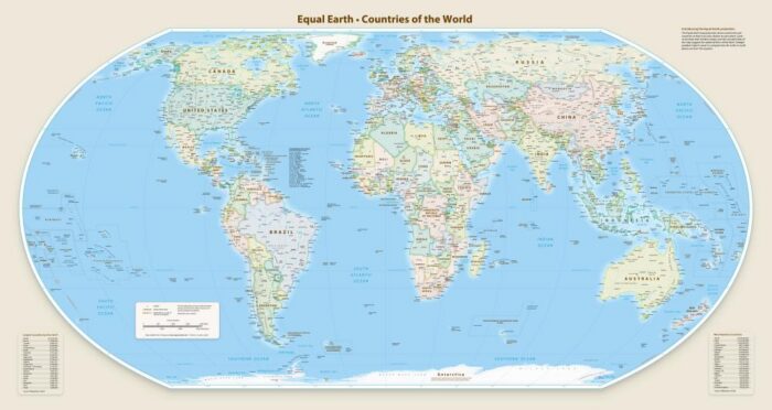
The proposed replacement is based on the 2018 Equal Earth map, designed by an international team of cartographers. Unlike the Mercator projection, it aims to preserve the relative size of land areas.
Togo’s Foreign Affairs Minister Robert Dussey described the issue as scientific rather than political.
“This discussion is not a political discussion [but] a scientific discussion, because there is scientific proof so we all have to accept the reality,” he said, as quoted by the Guardian.
For Africa, however, the debate carries a deeper meaning.
Supporters argue that repeatedly seeing the continent represented as smaller than it is may have influenced how people understand Africa’s place in the world, from classrooms to global politics and economics.
JJ Enoch, a geopolitical risk adviser, said adopting an equal-area map would provide “a more accurate basis for education and public understanding”.
But Kenyan classrooms will not necessarily wake up to new maps immediately.
UN resolutions are not legally enforceable, meaning countries and institutions will not be compelled to abandon the Mercator projection.
Still, the vote could influence school curricula, technology and other systems where world maps are widely used.
For Dussey, the message is simple: Africa should no longer allow an old picture to define how the world sees it.
“It is time for us to change the narrative,” he said.